UAV Thermal Imaging in Climate Change Research
Inadequate access to water threatens the lives and livelihoods of billions of the world’s poor. It’s no stretch to say that strategies for mitigating and adapting to this reality are urgently needed. Enter the Workswell WIRIS ProSc thermal imaging camera. This highly stable, exceptionally sensitive instrument delivers accurate surface temperature measurements over large areas. It is an ideal aid in the visualization of thermal processes across a landscape. This information is critical in the fight against water insecurity because healthy vegetation is a necessary precondition of a reliable water supply. To ensure the vitality of local vegetation, professionals need an effective tool to track the effects of their efforts.
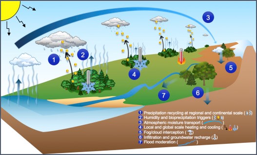
The water cycle also has a profound impact on climate change. Although it receives almost exclusive attention, the “greenhouse effect” is not the only cause of climate change. In fact, warming due to changes in land cover (vegetation) may explain as much as 18% of current global warming trends. This highlights the necessity of placing water and energy cycle feedback mechanisms at the center of reforestation efforts and other forest-based mitigation goals [1], [2]. Forest and vegetation restoration can positively impact water and energy cycles, stabilize local temperatures, and improve water availability.
Consequences for the Local Climate
Microclimates are affected by the type and distribution of local vegetation, as well as by regional soil conditions. The water retention properties of soil play a particularly important role in regulating local ground surface temperature, as well as local air temperature. These microclimatic factors have their own profound effect on local vegetation.
While vegetation is widely recognized as a potential store of carbon, it also provides a broad range of less appreciated benefits that are equally, if not more, important. Indeed, carbon sequestration can, and perhaps should, be viewed as just one positive effect of reforestation strategies designed to protect and intensify the hydrologic cycle and its associated cooling. By evapo-transpiring, trees recharge atmospheric moisture, contributing to both local and regional rainfall. What’s more, cooling is explicitly embedded in trees’ capacity to capture and redistribute solar energy. This effect can be clearly observed with our Workswel WIRIS ProSc thermal imager, as shown in Figure 1.


See in full resolution (4 MB)
Figure 1.: Orthothermogram describing the (local) climatic situation in southern Moravia in the Czech Republic (Central Europe). Captured by the Workswell WIRIS ProSc thermal imaging camera.
The beneficial role that forests play in regulating water and climate at the local, regional and continental scales through the changes they effect in hydrologic and energy cycles is a scientific fact (see Figure 2). Yet when it comes to convincing millions of people about a reforestation strategy, a picture says more than a thousand words.
Vegetation is Linked to Rainfall and Water Availability
In addition to local action, both regional and continental policy-making frameworks are necessary for the adequate consideration of transboundary forest, water, and energy cycle interactions. The Workswell WIRIS ProSc provides an informative visual aid in the negotiation of climate strategies.
We believe that our Workswell WIRIS ProSc thermal imaging camera has a role to play in the process of climate change adaptation and mitigation through land use and water management. These efforts will determine humanity’s ability to protect our planet’s life-sustaining functions.
The orthothermogram on the left (Figure 1) is composed of 1500 separate thermograms (with 90% overlap), which were acquired by the Workswell WIRIS ProSc thermal camera and composed in Pix4Dmapper software. The orthothermogram maps an area of approximately 5 hectares (50,000 m2), and was taken by a drone during two separate flights (total flight time 50 min.) from a height of 70 m. This orthothermogram accurately describes the (local) climatic situation in southern Moravia in the Czech Republic (Central Europe).
Using a separate RGB image, we can use this thermogram to interpret an area of 5 hectares with huge temperature contrasts. We can also take corrective actions and monitor their impact over time.
The Workswel WIRIS ProSc is the only UAV thermal imaging camera that meets all the requirements of this extremely demanding application. The main requirements are:
- high thermal sensitivity (< 30 mk)
- very low temperature drift, even during long flights
- very high thermogram homogeneity
Water and plant management influence the local microclimate. By draining and removing greenery over large areas, we induce a desert climate, especially in cities and fields, that cannot be resolved through purely technical means.
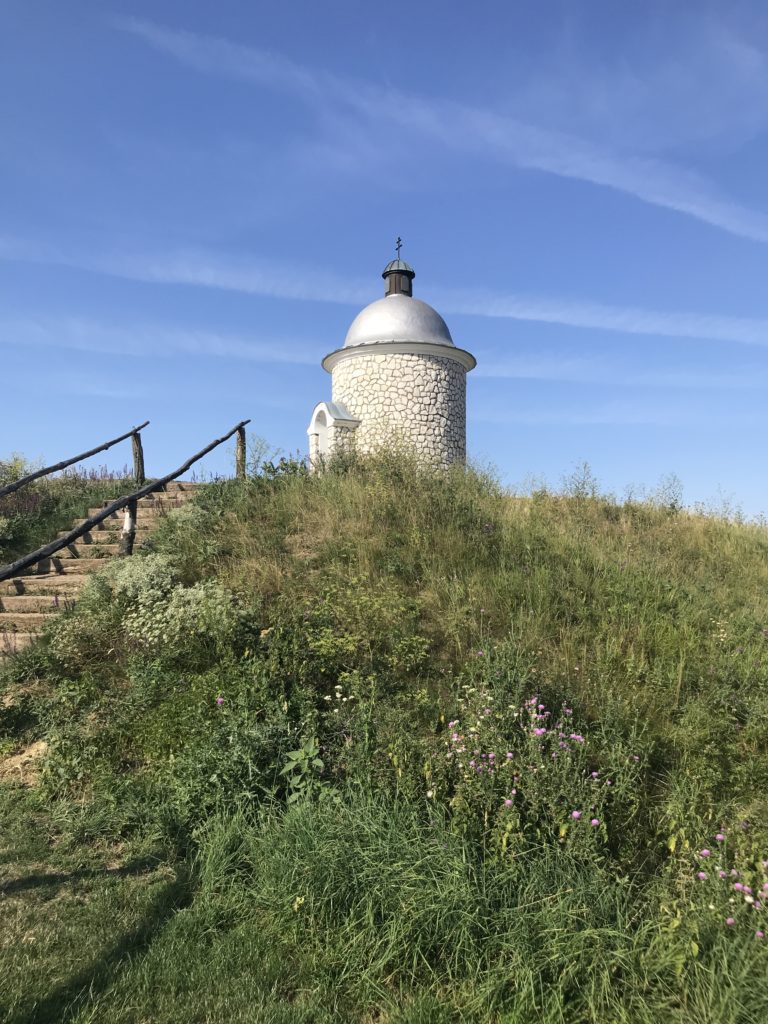
Thanks to this image, it is clear where landscape drought and vegetation loss originate. We can see that the naked hill (affected by intense soil erosion) on the right above the vineyard warms its surroundings and heats the interior of the vineyard.
On the other hand, the vegetation to the left of the vineyard has a cooling effect, even within its immediate vicinity, which also penetrates into the vineyard, which covers an area of approximately 2 ha. The picture indicates what remedial action should be taken and where it will be easiest to start restoring vegetation.
Conclusion
We believe that the Workswell WIRIS ProSc thermal camera is a useful tool for land management. With its help, it is possible to localize, visualize, and reverse processes which are currently considered to be locally irreversible because they are perceived as manifestations of global changes.


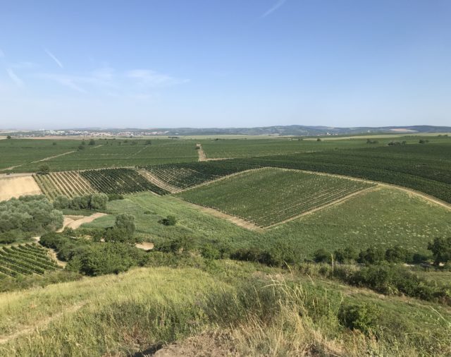
Figure 3.: This high-resolution ortothermogram, composed from over 650 separate thermograms in Pix4D, visualizes a vineyard with an area of 1.4 hectares. The picture was taken by the WIRIS Pro during a single flight with a total flight time of 15 minutes.
References
Special thanks to Doc. RNDr. Jan Pokorný, CSc. from the ENKI institute. We drew on his lectures and education materials to craft this text.
[1] R. Alkama, A. Cescatti, et al., Biophysical climate impacts of recent changes in global forest cover, Science, 351 (2016), pp. 600-604,
[2] DavidEllison, Cindy E.Morris, et al., Trees, forests and water: Cool insights for a hot world, Global Environmental Change Volume 43, March 2017, Pages 51-61